-
Doomwalker

- Brigadier General
- Posts: 449
- Joined: Mon Apr 30, 2007 4:36 am
- Location: Confederate held territory in Afghanistan.
-
epaminondas
- Colonel
- Posts: 362
- Joined: Thu Feb 08, 2007 9:35 pm
Doomwalker wrote:Nice work on the updates in Alabama. I do wish that the Selma connection could be built in game.
I agree.
I guess it's the developer's continuing dilemma - every improvement made creates the demand for something more. In this case, Gray's epic rework of the railways has vastly improved the historicity of the game, but in so doing has made the need to be able to actually build railroads all the more acute.
-
Gray_Lensman

- Posts: 497
- Joined: Mon Jun 18, 2007 4:04 am
- Location: Who is John Galt?
-
Chamberlain

- Captain
- Posts: 182
- Joined: Wed Apr 18, 2007 7:46 pm
- Location: New York
Hello Gray_Lensman,
Is this new download (20080111) on a new download site ?
The download is crawling like 2 updates ago. It is nowhere near the speed of the 20080109.
Just wanted to let you know in case you are not aware of it.
Transfer rate averaging 56 to 57 KB
Thanks,
Chamberlain
** Update - download took 10 min. 10 sec with Cable modem
-
Gray_Lensman
- Posts: 497
- Joined: Mon Jun 18, 2007 4:04 am
- Location: Who is John Galt?

Just took a good look at this for the first time and I'm bowled over. This is very impressive, and shows what modding is really all about.
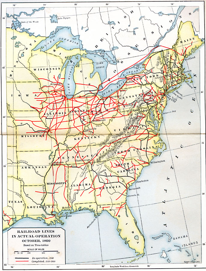
Out of curiosity, just how accurate were the maps in Shelby Foote? Did he review them himself in detail, or was it something between the publisher and their art department? I met a retired mapmaker from a publishing house once, and all she had done for thirty-odd years was make maps for books in different styles. I wish I had paid closer attention at the time, but my recollection is that she was more concerned with the look and style of a map than its contents (in other words she was an artist rather than an historian). If Foote wasn't heavily involved with his maps, this kind of thing could have quite an impact. He probably was because his maps look very convincing, but cross-checking them with 19th century sources is very reassuring.
The other thing I'm wondering is how many choke-points in the east-west railnet in the Confederacy were there? Was it possible to board a train somewhere along the Mississippi and get off in Richmond? I was always under the impression that the net may have been very easy to break into non-interconnecting pieces somewhere to the northwest and southwest of Georgia (ferries across unbridged river crossings ?).

Philippe wrote:The other thing I'm wondering is how many choke-points in the east-west railnet in the Confederacy were there? Was it possible to board a train somewhere along the Mississippi and get off in Richmond? I was always under the impression that the net may have been very easy to break into non-interconnecting pieces somewhere to the northwest and southwest of Georgia (ferries across unbridged river crossings ?).
As far as I know, there were choke points as you describe, but I'm not sure where to get data.
One kind of choke point that I do have data: the three different railroad gauges that exited in the south! I have a Map from the West Point Military History series that shows 4'8.5", 5'0' and 5'6" rr. Interstingly, the majority is 5'0". (The 'main line' from Norfolk through Knoxville and Chatanooga was 5'0).
So a different kind of choke point existed: unload from a 'standard gauge' train and load onto a 'wide gauge train'. Sadly, the map is 11x18, so I'd have to scan in sections. (Can do if you wish). Also, the colors got printed incorrectly, and are somewhat offset from each other.

-
Gray_Lensman
- Posts: 497
- Joined: Mon Jun 18, 2007 4:04 am
- Location: Who is John Galt?
-
Gray_Lensman
- Posts: 497
- Joined: Mon Jun 18, 2007 4:04 am
- Location: Who is John Galt?
Gray, I am about to integrate your railroad work into my PBEM mod.
I will need to upgrade the cities file and regenerate a new scenario to integrate your work. Do you happen to have a list available of all completed regions which either have added railroad capability or have had railroad capacity removed?
Or are your changes available in a cities XLS file? If so, I could simply cut and paste the transportation level from your XLS into mine.
My intent is to include all changes up to today or possibly through this weekend.
Any help would be appreciated in reducing the number of hours in completing this transfer of your work into the PBEM mod.
Thanks!
-
Gray_Lensman
- Posts: 497
- Joined: Mon Jun 18, 2007 4:04 am
- Location: Who is John Galt?
-
Gray_Lensman
- Posts: 497
- Joined: Mon Jun 18, 2007 4:04 am
- Location: Who is John Galt?
Gray_Lensman wrote:Jagger:
The absolute latest copy of the AACW_DB_Regions.xls file was just posted in Clovis' "Coming Fury MOD" thread near the end. It has all the changes since v1.07i and they are highlighted in Yellow. Copy and paste is the best way to avoid any clumsy keying (I do it that way myself for the 8 vanilla scenarios and bigus' 3 scenarios). Be sure to copy the data from both the "Transport_level" column and the "CityName" column. I just made 2 changes in the CityName column to effect structure name changes in North Carolina. See next post below.
I'll also create an attachment to the first post in this thread that I will keep updated with the latest AACW_DB_Regions_v1.07i & RR MODS.xls file just for you other Modders.
Thanks Gary! That will save me a huge amount of time!
-
Gray_Lensman
- Posts: 497
- Joined: Mon Jun 18, 2007 4:04 am
- Location: Who is John Galt?

Gray_Lensman wrote:AACW RR Accuracy MOD 20080117 (fast install).zip just posted
This latest upload completes the first half or so of the RR MOD and is being presented to AGEod for "officialization" at this point. See the first post in this thread for details.
Links to all-inclusive (fast-install) AACW RR Accuracy MOD:
http://www.mediafire.com/?fgju1gmmxjt (reportedly faster link, when it's operating)
http://www.savefile.com/files/1243354 (alternate link, but sometimes slower for overseas users)
Enjoy.
Gray,
By 'sometimes slower for overseas users', I assume that you are in the US and therefore I would be overseas.
[SIGPIC][/SIGPIC]
'Nous voilà, Lafayette'
Colonel C.E. Stanton, aide to A.E.F. commander John 'Black Jack' Pershing, upon the landing of the first US troops in France 1917
'Nous voilà, Lafayette'
Colonel C.E. Stanton, aide to A.E.F. commander John 'Black Jack' Pershing, upon the landing of the first US troops in France 1917
-
Gray_Lensman
- Posts: 497
- Joined: Mon Jun 18, 2007 4:04 am
- Location: Who is John Galt?
Gary, I found something odd after installing your latest version. Two regions north of Bowling Green were showing the icon for distroyed tracks and there are no longer tracks there. When I mouse over the regions their pop ups show that there is Railroad there. But, when I travel through the regions no railroad travel is available. I do not know how to do screenshots so I hope this is clear? Odd.
-
AndrewKurtz
- Posts: 1167
- Joined: Tue Jan 30, 2007 2:49 am
- Location: Greenville, SC
gbs wrote:Gary, I found something odd after installing your latest version. Two regions north of Bowling Green were showing the icon for distroyed tracks and there are no longer tracks there. When I mouse over the regions their pop ups show that there is Railroad there. But, when I travel through the regions no railroad travel is available. I do not know how to do screenshots so I hope this is clear? Odd.
Any chance this a saved game? I think I saw this once on a saved game where I updated the regions.
-
Gray_Lensman
- Posts: 497
- Joined: Mon Jun 18, 2007 4:04 am
- Location: Who is John Galt?
Gray_Lensman wrote:If this is a saved game that was continued after installing the RR MOD, then you will find odd discrepancies like these, due to the fact that the saved game internal RR information no longer agrees with the on-map display. I have cautioned against that in various threads.
Also, you have to be more specific, there are at least 2 Bowling Greens on the map or at least I think there are. Yep, Bowling Green KY and Bowling Green VA.
There are 2 regions north of Bowling Green VA, Charles MD (Port Tobacco) and St Mary's MD (Leonardtown) that had RRs removed in the RR MOD, so if you are playing a saved game, this type of error would show up there. It is best to finish saved games, before applying the RR MOD to avoid these conflicts as there is nothing that can be done about games in progress.
Yes this was a saved game that was continued after the install of the mod. That probably explains it.
The two regions are the ones that the old rail line ran through above Bowling Green KY that ran to the city in Indiana, I think. I am at work now.
-
Gray_Lensman
- Posts: 497
- Joined: Mon Jun 18, 2007 4:04 am
- Location: Who is John Galt?

Gray...recently I've been reading Battles And Leaders Of The Civil War.
I was checking out the maps in the Missouri section when I happened to notice No rail line from Hill MO to Charleston MO. Since the book was written in 1884 I'm not sure if this was a 61 battle map or not. I'm not sure but I think most of the Maps were drawn from the period of the actual conflict. Here is the line in question. I know the line from St Louis to Ironton was there.
[ATTACH]1715[/ATTACH]
[ATTACH]1716[/ATTACH]
bigus
- Attachments
-
-
-
Gray_Lensman
- Posts: 497
- Joined: Mon Jun 18, 2007 4:04 am
- Location: Who is John Galt?

Gray_Lensman wrote:It's already been noticed by me, since I live in MO, and it's also confirmed by "The Official Military Atlas of the Civil War". I just haven't got to MO yet, because I was on vacation for the last 2 weeks and I'm concentrating my current efforts on the northern states, (currently NJ), since I have to utilize the internet RR maps for my data. (the northern states are not covered very well, if at all, in the "Atlas")
Starting tomorrow, I'm back to work where I don't have internet access and will instead work on those states that are displayed in the "Atlas" mentioned above, of which MO is one. The "Atlas" may be a huge book, but at least I can cart it to work.
Thanks for the heads up though.
FYI. The current Gov. Blunt of MO is the son of a MO U.S. representative Blunt, both of whom live in the Springfield MO area. Interesting, eh. Wonder if they are descendants of General Blunt who fought in that area. Hmmm. As if that's a hard one to guess.
[LEFT]Disabled
[CENTER][LEFT]
[/LEFT]
[LEFT]SVF news: http://struggleformodding.wordpress.com/
[/LEFT]
[/CENTER]
[/LEFT]
[CENTER][LEFT]
[/LEFT]
[LEFT]SVF news: http://struggleformodding.wordpress.com/
[/LEFT]
[/CENTER]
[/LEFT]
-
Gray_Lensman
- Posts: 497
- Joined: Mon Jun 18, 2007 4:04 am
- Location: Who is John Galt?
-
Gray_Lensman
- Posts: 497
- Joined: Mon Jun 18, 2007 4:04 am
- Location: Who is John Galt?
-
Gray_Lensman
- Posts: 497
- Joined: Mon Jun 18, 2007 4:04 am
- Location: Who is John Galt?
-
Brausepaul
- Sergeant
- Posts: 65
- Joined: Mon Dec 10, 2007 6:25 pm
-
Gray_Lensman
- Posts: 497
- Joined: Mon Jun 18, 2007 4:04 am
- Location: Who is John Galt?
Who is online
Users browsing this forum: No registered users and 19 guests