User avatar
Syt
Colonel
Posts: 322
Joined: Tue May 01, 2007 6:41 am
Location: Vienna

The Map/Names of German towns

Thu Nov 15, 2007 7:59 am

I love the beautiful map, and all the more grating it was when I looked at Austria in the 1809 camapign:
Image
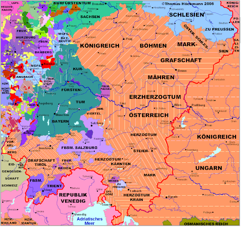
I think there's an r too much .... it should be Kärnten. But as that's in the map graphics I guess it's too late to change it.


I love that the German towns have their original German names (with Umlauts! :niark: ), and that Glückstadt (I live in Vienna, but grew up near Glückstadt) is included. :D

I have a few nitpicks, though, please bear with me:
- Innsbrück (town/province). I believe it should be Innsbruck (no Umlaut)
- Nuremberg (town). If all other town names are local language, then this should be Nürnberg - the province is correctly named.
- Koenigsberg (province). The town has it correct (Königsberg), the province is with oe instead.
- Kustrin (town). The province has the correct name (Küstrin), the town is lacking the Umlaut.
- Kitzbuhl (region). Should be Kitzbühel.
- Gyor (province). Should be Györ (on town map icon is also wrong).
- Karntern (region). Should be Kärnten.
- Osterreich (region). Should be Österreich.
- Bolzen (town icon). Province is correctly names Bozen.
- Nordlingen (town icon). Should be Nördlingen (province is correctly named).
- Luneburg (town icon). Should be Lüneburg (province is correctly named).
- Koniggrätz (province). Should be Königgrätz (town has it correct).
- Halberstad (town icon). Should be Halberstadt (province name is correct).
- Osnabruck (town icon). Should be Osnabrück (province is correct).
- Gorlitz (province). Should be Görlitz.
- Olmutz (town). Should be Olmütz (province is correct).
- Koln (province). Should be Köln (town is correct).

- Sarrebruck. Debatable. The province belongs to "Pfalz, Germany", so maybe using the German name (Saarbrücken) for province and town would be better? Then again, Sarre is "living between the worlds", so to speak. :)

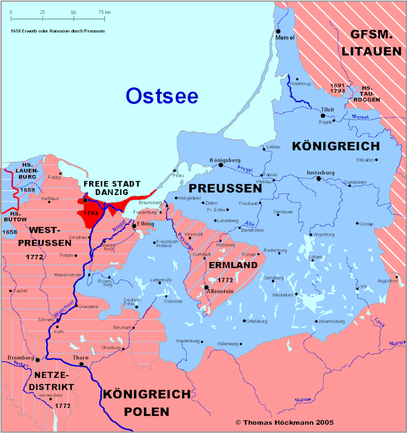
The towns in Bohemia and Morava have German names, and the region is considered part of Germany, so probably the regions should also be renamed (Böhmen, Mähren)? Other German regions also have German names (West Preussen, Bayern, Schwaben). :)

Sorry to be so pedantic, I guess my profession (accountant) does start to affect my character. :o
[SIGPIC][/SIGPIC]
The brutality and inhumanity of war stood in great contrast to what I had heard and read about as a youth.
- Reinhold Spengler, war volunteer 1st Bavarian Infanterie Regmnt., 1916

User avatar
PhilThib
Posts: 13705
Joined: Tue Oct 18, 2005 5:21 pm
Location: Meylan (France)

Thu Nov 15, 2007 8:31 am

Thanks for the input... that's very interesting and we shall include the changes when we do the first major map update (there will be one, I just wait to collect more such data :niark: )...

It was very difficult for us to get the proper historical names in German, especially on regions that no longer are / speak German... so we are happy when someone finds valuable stuff....

Everything related to those "German" parts / names of XIXth century Bohemia, Poland and even Hungary will be welcome :indien:

Tirailleur
Private
Posts: 22
Joined: Tue Jan 09, 2007 7:02 pm
Location: Germany - Bielefeld

Thu Nov 15, 2007 8:59 am

I do not know if it is possible and it's some sort of hairsplitting, but the more correct notation of Prussia in German is Preußen instead of the ss.

User avatar
PhilThib
Posts: 13705
Joined: Tue Oct 18, 2005 5:21 pm
Location: Meylan (France)

Thu Nov 15, 2007 9:47 am

I know, but Windows does not handle the Szet properly... :p leure:

User avatar
Syt
Colonel
Posts: 322
Joined: Tue May 01, 2007 6:41 am
Location: Vienna

Thu Nov 15, 2007 9:54 am

PhilThib wrote:Thanks for the input... that's very interesting and we shall include the changes when we do the first major map update (there will be one, I just wait to collect more such data :niark: )...

It was very difficult for us to get the proper historical names in German, especially on regions that no longer are / speak German... so we are happy when someone finds valuable stuff....

Everything related to those "German" parts / names of XIXth century Bohemia, Poland and even Hungary will be welcome :indien:


I have a 2-volume Brockhaus encyclopedia from 1910 on my shelf. I can look up some fo the lands/towns/regions which were at the time part of Germany or Austria-Hungary and post any further variants here, if you like. :)
[SIGPIC][/SIGPIC]

The brutality and inhumanity of war stood in great contrast to what I had heard and read about as a youth.

- Reinhold Spengler, war volunteer 1st Bavarian Infanterie Regmnt., 1916

User avatar
PhilThib
Posts: 13705
Joined: Tue Oct 18, 2005 5:21 pm
Location: Meylan (France)

Thu Nov 15, 2007 10:28 am

Please do so....it can even help me for a few other (secret and non-secret) projects.... e.g. Vainglory of Nations :cwboy:

Tirailleur
Private
Posts: 22
Joined: Tue Jan 09, 2007 7:02 pm
Location: Germany - Bielefeld

Thu Nov 15, 2007 10:34 am

Hello PhilThib,

there is a German webside http://www.hoeckmann.de/deutschland/index.htm, there are a few pictures of maps from Germany and the countries around from the end of the 18th century. Some a very detailed, I think it can help little bit.

Historische Karten - Deutschland am Ende des 18. Jahrhunderts
Historical maps - Germany at the end of the 18th century
Cartes historiques - L´Allemagne à la fin du XVIIIe siecle

On this side http://www.hoeckmann.de/download/phatlas.htm, you have also a demo version, where you can see the province names of Europe around 1800 (the Germans in German). You have to click "kostenlose Demo-Version zum Herunterladen" and to download the demo version.
If you zoom in, you can also see more town and city names.

I must clarify, that I've nothing to to with the products on the side.

Tirailleur
Private
Posts: 22
Joined: Tue Jan 09, 2007 7:02 pm
Location: Germany - Bielefeld

Fri Nov 16, 2007 7:53 am

Here are some examples:

Germany 1789 Atlas
Image
Image

Periodical Historical Atlas of Europe
Image

User avatar
PhilThib
Posts: 13705
Joined: Tue Oct 18, 2005 5:21 pm
Location: Meylan (France)

Fri Nov 16, 2007 8:48 am

Great :coeurs:

User avatar
Syt
Colonel
Posts: 322
Joined: Tue May 01, 2007 6:41 am
Location: Vienna

Fri Nov 16, 2007 9:57 am

Nice maps, Tirailleur. :)

It doesn't quite fit in here, but I think it also doesn't really warrant its own thread:

I noticed that the German militias are frequently spelled "Landwher". Correctly, it would be Landwehr. :)
[SIGPIC][/SIGPIC]

The brutality and inhumanity of war stood in great contrast to what I had heard and read about as a youth.

- Reinhold Spengler, war volunteer 1st Bavarian Infanterie Regmnt., 1916

Tirailleur
Private
Posts: 22
Joined: Tue Jan 09, 2007 7:02 pm
Location: Germany - Bielefeld

Fri Nov 16, 2007 8:43 pm

I hope you can correct some of the minor nations... :siffle:

For example the city Paderborn was never before a part of the province Hessen. It was a part of Westphalia (German old: "Westphalen", today: "Westfalen").

If it was a decision of merging, then I would say instead of Hessen call the province Westphalen, 'cause it was the bigger province in that time.

If have a good source on the web with original maps:

http://alabamamaps.ua.edu/historicalmaps/index.html

It is an historical map archive. The most are from USA, but some good one are from rest of the world. If you look under Europe, you can make a more precise selection.
Under "Germany, Prussia & Poland", then under "Germany", you can find a map of Germany from 1810: "General-Charte van Teutschland". If you zoom in, you can find the province frontiers with their names and many towns. (If you install the plugin you can make a full window view by right click the mouse and the possibility to print).

This is only the selection picture of the map, that opens in an new window, where you can zoom in and pan around:
Image

Return to “Help to improve NCP!”

Who is online

Users browsing this forum: No registered users and 5 guests