-
Gray_Lensman

- Posts: 497
- Joined: Mon Jun 18, 2007 4:04 am
- Location: Who is John Galt?
-
Gray_Lensman
- Posts: 497
- Joined: Mon Jun 18, 2007 4:04 am
- Location: Who is John Galt?
-
Gray_Lensman
- Posts: 497
- Joined: Mon Jun 18, 2007 4:04 am
- Location: Who is John Galt?
-
Gray_Lensman
- Posts: 497
- Joined: Mon Jun 18, 2007 4:04 am
- Location: Who is John Galt?
-
Gray_Lensman
- Posts: 497
- Joined: Mon Jun 18, 2007 4:04 am
- Location: Who is John Galt?
-
Gray_Lensman
- Posts: 497
- Joined: Mon Jun 18, 2007 4:04 am
- Location: Who is John Galt?
-
Gray_Lensman
- Posts: 497
- Joined: Mon Jun 18, 2007 4:04 am
- Location: Who is John Galt?
-
Gray_Lensman
- Posts: 497
- Joined: Mon Jun 18, 2007 4:04 am
- Location: Who is John Galt?


-
Chamberlain

- Captain
- Posts: 182
- Joined: Wed Apr 18, 2007 7:46 pm
- Location: New York

Thanks for the shots. I've been wanting to go on a battlefield tour for the past few years before they all disappear, but I'm always lacking the time or money. I have a bunch of old Polaroids from when I was younger, but those things deteriorate so quick, most are barely visible anymore. I'd like to go with a good digital camera and preserve some good pics for the future when they finally put that shopping mall and parking lot right on top of Cemetary Ridge . 
Official Queen's Ambassador to the South
[SIGPIC][/SIGPIC]
[SIGPIC][/SIGPIC]
Thanks Grey! I'll be back in BIG MO this May and June, and I've been invited to a wedding in Hot Springs in June, so I plan to make a trip to at least one of those battle fields...that is if the missus will allow it!...
My family is from Keytesville area, so I have always been familiar with Sterling Price and his history. I have attended a few "Sterling Price Days" in town! Good old fashioned fun!
My family is from Keytesville area, so I have always been familiar with Sterling Price and his history. I have attended a few "Sterling Price Days" in town! Good old fashioned fun!
Wow...incredible stuff Gray. I'm a proud Missourian and think this whole area, including down south in Arkansas, has some of the best Civil War heritage left.
I've visited Gettysburg and Fredricksburg, but that's about it. Shame on me for I have yet to visit either Wilson's Creek or Lexington here in Missouri.
Awesome stuff Gray.
I've visited Gettysburg and Fredricksburg, but that's about it. Shame on me for I have yet to visit either Wilson's Creek or Lexington here in Missouri.
Awesome stuff Gray.
[SIGPIC][/SIGPIC]Have you ever stopped to think and forgot to start??
 apy:
apy:-
Aphrodite Mae

- Posts: 764
- Joined: Fri Sep 05, 2008 3:13 pm
- Location: With Dixicrat
 Thanks, Gray!
Thanks for the pictures, Uncle Gray!
I can't say exactly why, but they evoke strong feeling. "Thoughtful sadness", I guess is the best way to describe what I feel.
I hope you enjoyed your trip, and had fun!
By the way, folks: today is the 144th anniversary of Lee's surrender at Appomattox. Here's a link to an article: Surrender at Appomattox.
-
gchristie

- Brigadier General
- Posts: 482
- Joined: Wed Jan 23, 2008 5:31 pm
- Location: On the way to the forum
Looking west
Thank you for sharing these pictures.
As an easterner I don't know when I would get the chance to tour the western battle fields. Last summer I took my teenage kids to Gettysburg. Somber is the word I would apply to how the experience made us feel, and these photos evoke the same feeling. And though the term is cliche, "hallowed ground" comes to mind.
I was also struck by how low the high ground was. Reading accounts of the battles, the high ground in my mind's eye is much higher than was the reality - but tell that to the attackers.
"Now, back to Rome for a quick wedding - and some slow executions!"- Miles Gloriosus

-
Chaplain Lovejoy

- Brigadier General
- Posts: 440
- Joined: Sun Mar 30, 2008 12:20 am
- Location: Fairfield, OH (near Cincinnati)
-
Gray_Lensman
- Posts: 497
- Joined: Mon Jun 18, 2007 4:04 am
- Location: Who is John Galt?

Great pictures!
Aphrodite Mae wrote:Thanks for the pictures, Uncle Gray!
I can't say exactly why, but they evoke strong feeling. "Thoughtful sadness", I guess is the best way to describe what I feel.
I hope you enjoyed your trip, and had fun!
+1
It's one thing to look at pictures in ACW books and webpages, and quite another to look at pictures that your friends have taken. For me, at least, it gives an added depth to what I see. (Even better, you can ask questions!)
For those of you who enjoy visiting National Military Parks of the ACW, I'd like to recommend a reference guide to identifying the guns and howitzers that you'll see there.
Field Artillery Weapons of the Civil War
This guide is a classic of the genre. One of the great things about it is that it enables you to identify a particular weapon that you see on your trip... and learn about its unique history! (Where it was made, when, and so on.)
Once you're able to identify the gun, you can conduct further research with other sources and learn which units the weapon was assigned to, and even what battles it played a part in.
Thanks again, Gray, for sharing these inspiring pictures.
Dixicrat
PS @Chaplin Lovejoy: I think you're right!
For those who don't know, "Mountain" weapons are so called because the components of the gun could be quickly disassembled to be transported by horse, along narrow trails which a limbered gun could not have passed. Notice how the wheels are much smaller, for example.
In post number 5, if you examine the lower left picture in the display on the wall behind the howitzer, you can see how a horse has been loaded with the gun carriage.
-
TheDoctorKing

- Posts: 1664
- Joined: Thu Apr 24, 2008 12:56 pm
- Location: Portland Oregon
I'll be driving across the country this summer and I thought I'd visit some western battlefields that I've never been to - I'd like to see some Missouri sites, Island No. 10, Forts Henry and Donalson, and some Kentucky battlefields. I was also thinking of taking a "staff ride" through the Shennandoah Valley battlefields now that there's an "official" military park. Port Republic is right down the road from my mom's place and I drove through there for years without realizing that it was an important battlefield. And Cross Keys is nearby but so poorly known that people who live there don't know anything about the battle. I went looking for the site one time and spent about an hour poking around on farm roads before realizing that I'd been criss-crossing it the whole time!
I'll bring some pictures.
I'll bring some pictures.
Stewart King
"There is no substitute for victory"
Depends on how you define victory.
[SIGPIC][/SIGPIC]
"There is no substitute for victory"
Depends on how you define victory.
[SIGPIC][/SIGPIC]
-
TheDoctorKing
- Posts: 1664
- Joined: Thu Apr 24, 2008 12:56 pm
- Location: Portland Oregon
Hmmm, looks like Is. No. 10 isn't there any more; probably the river changed course? And Fort Henry isn't there on account of there's this huge honking dam right downstream... Fort Donelson is still around but I'm noticing that the river seems higher and I bet there's been some flooding from those dams there too.
Any suggestions on ACW sites in Kentucky to visit?
Any suggestions on ACW sites in Kentucky to visit?
Stewart King
"There is no substitute for victory"
Depends on how you define victory.
[SIGPIC][/SIGPIC]
"There is no substitute for victory"
Depends on how you define victory.
[SIGPIC][/SIGPIC]
-
Chaplain Lovejoy
- Brigadier General
- Posts: 440
- Joined: Sun Mar 30, 2008 12:20 am
- Location: Fairfield, OH (near Cincinnati)
-
Doomwalker

- Brigadier General
- Posts: 449
- Joined: Mon Apr 30, 2007 4:36 am
- Location: Confederate held territory in Afghanistan.
Great pics.
Thank you for sharing Grey, I love getting to see the battlefields today. Unfortunately, most have not been in person. But, thanks to you and others who get out and post the pictures of their adventures; I can see more than I would normally. 
[color="DarkGreen"][SIZE="2"]“We may be annihilated, but we cannot be conquered.”
- General Albert Sidney Johnston[/size][/color]
[SIGPIC][/SIGPIC]
[CENTER][color="DarkGreen"]AGEod's American Civil War Wiki - [/color][color="DarkGreen"]AACWWiki[/color][/CENTER]
- General Albert Sidney Johnston[/size][/color]
[SIGPIC][/SIGPIC]
[CENTER][color="DarkGreen"]AGEod's American Civil War Wiki - [/color][color="DarkGreen"]AACWWiki[/color][/CENTER]
-
mikee64

- Brigadier General
- Posts: 413
- Joined: Thu Jan 25, 2007 12:13 am
- Location: Virginia
- Contact: Website
Nice pics Gray.
I've got quite a few of Gettysburg. I'll post a few here now, and if there's interest I'll put up some more later - but not until after I go do my PBEM turn.
I apologize for the low quality, these are quite old and this was my very first digital camera. If you want to take a look at the park map to get an idea of the locations I was shooting from you can get it here: Gettysburg Park Map
This is the original McPherson's barn taken from McPherson's Ridge looking NE:
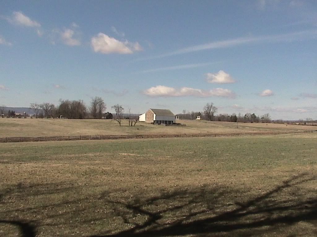
Just to the right of the barn you can see the Reynolds Monument, which sits along Chambersburg Pike. This is not where he was killed however; there is another Monument located in the woods to the left of the barn marking this spot.
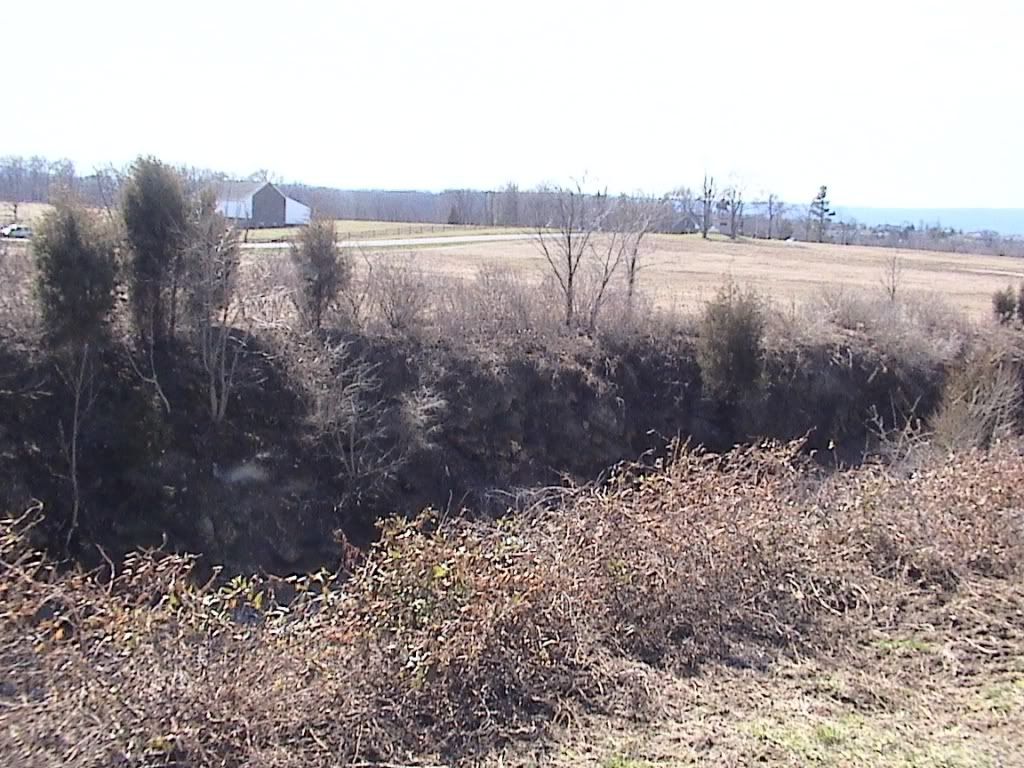
The next 3 are of the Railroad Cut:
Looking south towards the barn; Chambersburg Pike in middle, Reynolds Monument to the right of pike.
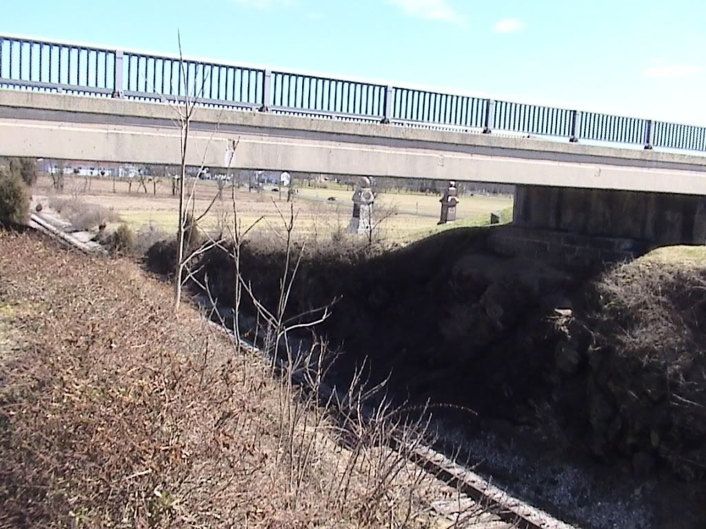
Looking East towards town.

Looking NE. Note the cut is no longer as deep or long as portrayed in period images.
This is looking south from Oak Ridge back to the barn at left middle:
The road in the foreground is Mummasburg Road. The road with cars coming towards the picture is part of the Park (Buford Ave.) and did not exist at the time of the battle. Notice how McPherson's Ridge is not really much of a "ridge" at all.
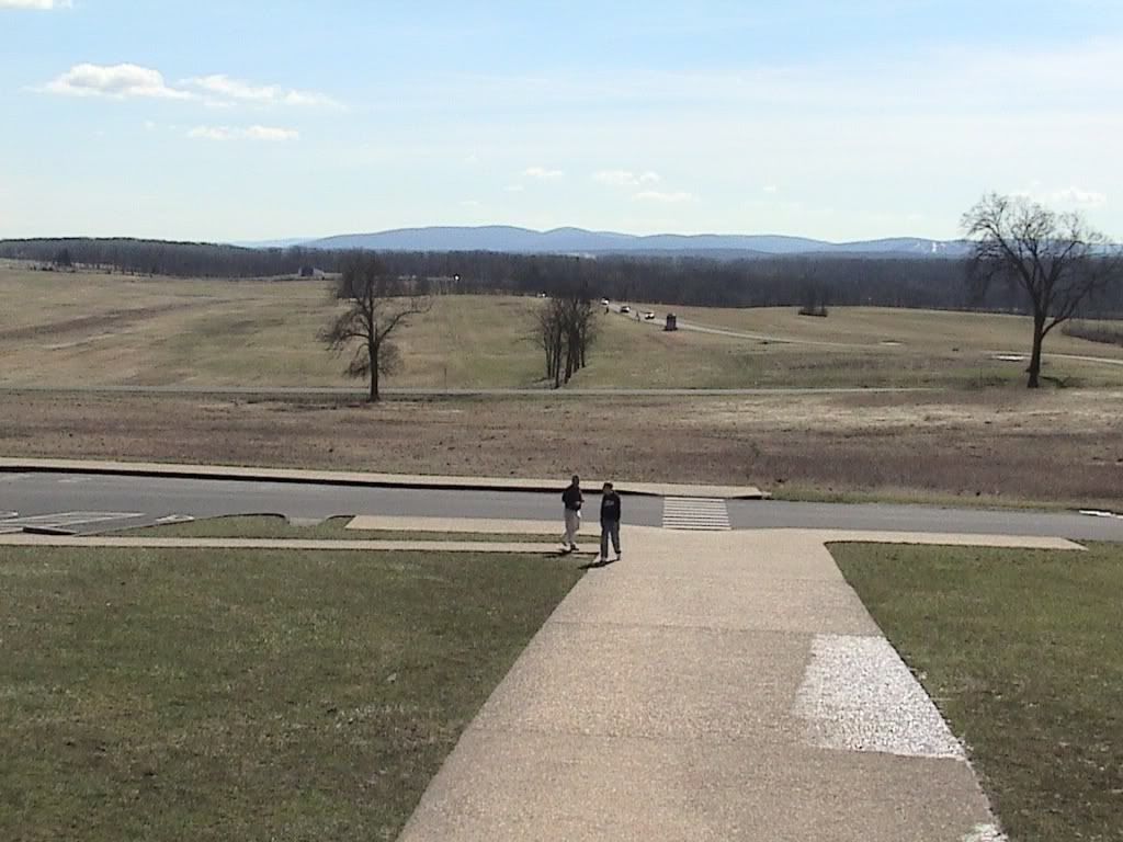
The next 2 are from the same spot on Seminary Ridge, looking towards Cemetary Ridge:
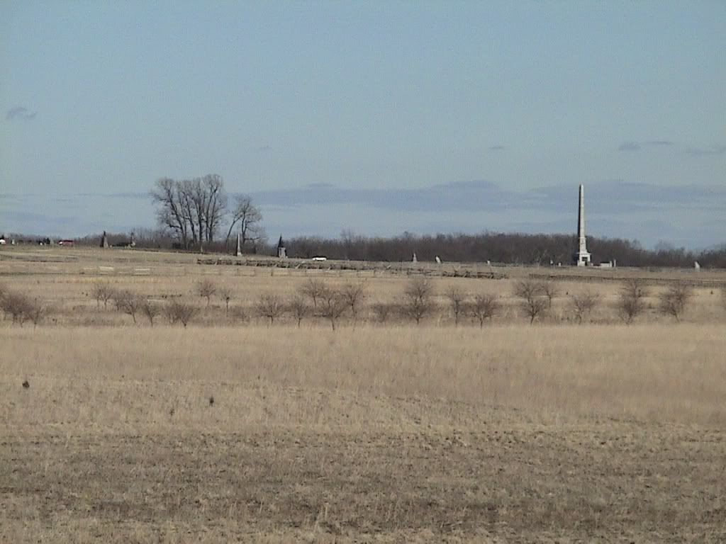
The "Copse of Trees" used as a guide during the charge is to the left. The large monument to the right is the Monument to the U.S. Regulars.
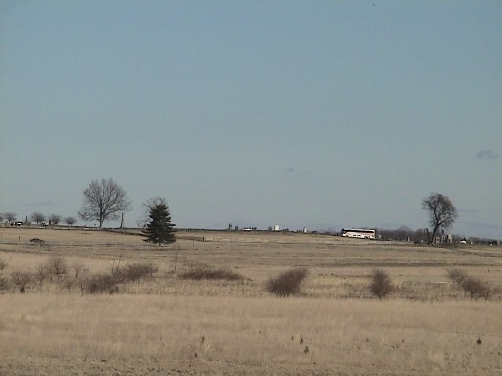
This is just to the North of the previous picture; you can really see the ridge start to rise more steeply here. This shot includes both "The Angle" and the "High Water Mark of the Confederacy". At left middle the car is traveling along Emmitsburg Road.
Lastly a look at Little Round Top from the same location:
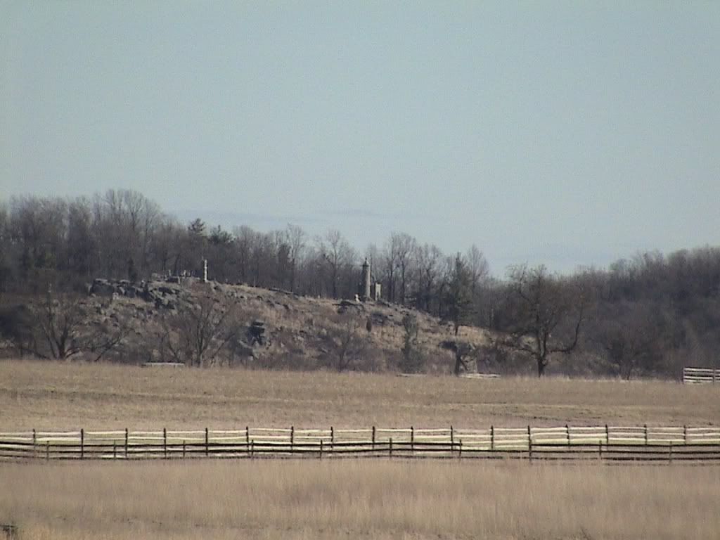
The fence runs along Emmitsburg Road.
Enjoy!
I've got quite a few of Gettysburg. I'll post a few here now, and if there's interest I'll put up some more later - but not until after I go do my PBEM turn.
I apologize for the low quality, these are quite old and this was my very first digital camera. If you want to take a look at the park map to get an idea of the locations I was shooting from you can get it here: Gettysburg Park Map
This is the original McPherson's barn taken from McPherson's Ridge looking NE:
Just to the right of the barn you can see the Reynolds Monument, which sits along Chambersburg Pike. This is not where he was killed however; there is another Monument located in the woods to the left of the barn marking this spot.
The next 3 are of the Railroad Cut:
Looking south towards the barn; Chambersburg Pike in middle, Reynolds Monument to the right of pike.
Looking East towards town.
Looking NE. Note the cut is no longer as deep or long as portrayed in period images.
This is looking south from Oak Ridge back to the barn at left middle:
The road in the foreground is Mummasburg Road. The road with cars coming towards the picture is part of the Park (Buford Ave.) and did not exist at the time of the battle. Notice how McPherson's Ridge is not really much of a "ridge" at all.
The next 2 are from the same spot on Seminary Ridge, looking towards Cemetary Ridge:
The "Copse of Trees" used as a guide during the charge is to the left. The large monument to the right is the Monument to the U.S. Regulars.
This is just to the North of the previous picture; you can really see the ridge start to rise more steeply here. This shot includes both "The Angle" and the "High Water Mark of the Confederacy". At left middle the car is traveling along Emmitsburg Road.
Lastly a look at Little Round Top from the same location:
The fence runs along Emmitsburg Road.
Enjoy!
Mike
-
Gray_Lensman
- Posts: 497
- Joined: Mon Jun 18, 2007 4:04 am
- Location: Who is John Galt?
-
Gray_Lensman
- Posts: 497
- Joined: Mon Jun 18, 2007 4:04 am
- Location: Who is John Galt?
Return to “ACW History Club / Histoire de la Guerre de Sécession”
Who is online
Users browsing this forum: No registered users and 7 guests